Welcome to Breeze Tech

Breeze Tech is a specialized technology provider focused on the sale, integration, and support of professional-grade drone systems for commercial, industrial, and government applications. We equip our clients with advanced UAV platforms and payloads for missions that demand precision, reliability, and performance.

Whether you’re building a drone program from the ground up or expanding your current capabilities, Breeze Tech supplies complete solutions—from multirotor and fixed-wing airframes to specialized sensors, flight software, and accessories.

In addition to our core equipment offerings, we also provide aerial LiDAR mapping and photogrammetry services as a value-added solution for clients who require on-demand terrain data, infrastructure surveys, or proof-of-concept deliverables prior to purchasing their own systems.

Drone Sales & Technical Integration

Our team supports the entire lifecycle—from equipment selection and procurement to custom integration, configuration, and field deployment.

Drone Sales & Technical Integration​

We provide turnkey drone solutions tailored to your operational needs, including:

  • LiDAR and photogrammetry payloads

  • Multispectral and thermal sensors

  • Fixed-wing and multirotor UAVs

  • RTK/PPK positioning systems

  • Mission planning and ground control stations

  • Portable charging and field deployment kits

Our team supports the entire lifecycle—from equipment selection and procurement to custom integration, configuration, and field deployment.

Training, Service, and Support

To ensure operational success, we offer:

  • Remote and on-site flight training

  • Sensor calibration and software setup

  • Maintenance and repair programs

  • Spare parts, upgrades, and diagnostics

  • Personnel support and Staffing Services


Breeze Tech supports clients across government, engineering, construction, energy, and agriculture sectors.

LiDAR Mapping Services

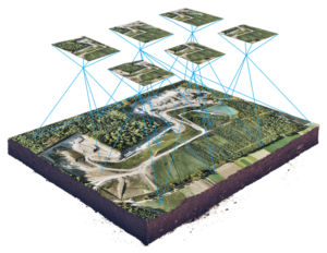
For clients without in-house aerial capacity, we offer contract LiDAR and geospatial survey services, including:

  • High-resolution terrain and elevation models

  • Corridor and infrastructure mapping

  • Digital surface and terrain models (DSM/DTM)

  • Orthomosaics and 3D reconstructions

Data is delivered in CAD, GIS, or BIM-compatible formats, with full processing and visualization included.

Command and Communications Systems

We supply secure and field-ready communications and coordination solutions, including:

  • VHF/UHF and satellite radios

  • Mobile command and control kits

  • Real-time telemetry relay

  • Ruggedized control interfaces

These systems are ideal for remote operations, public safety, and joint agency missions.

Contact Us

To request a quote, product catalog, or project consultation, reach out to our sales team. We look forward to supporting your next aerial operation.

Breeze Tech

6 Wingold Ave, Toronto, M6B 1P5, Canada

📧 info@breezetech.tech